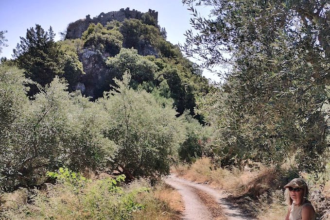
Agios Nicolaos, Anatoliki Mani, Laconia,Peloponnese
Castle of Bardounia
| Location: |
| On a hill near river Smynos and near Agios Nicolaos of East Mani, Peloponnese |
| Region > Prefecture: |  |
| Peloponnese Laconia | |
| Municipality > Town: | |
| City of Anatoliki Mani • Agios Nicolaos | |
| Altitude: | |
|
Elevation ≈ 325 m (Relative Height≈150 m) |
| Time of Construction | Origin | |
| 10th cent (?) | BYZANTINE |
|
| Castle Type | Condition | |
| Castle |
Rather Poor
|
A castle with Venetian and Ottoman features in south Laconia, in Peloponnese, at the borders with the territory of Mani.
Location & Strategic Scope
The strategic importance of the location lies in its proximity with Mani. The Ottomans needed the castle to contain the Maniates (the inhabitants of Mani) who never became subjects of the Ottoman empire.
History
It was initially a Byzantine castle built in the 9th or 10th century belonging to a network of castles that have been created then to control specific areas with Slav population.
It became a Frankish castle in the 13th century but around the end of that century, possibly in 1296, passed under the control of the Byzantines (of the Despotate of Mystras).
In 1460 it was captured by Mohamed II the Conqueror like the rest of the castle of Peloponnese. During the 1st Venetian-Turkish war (1463-1479) it was a Venetian stronghold. In that period -and before, maybe even from 1296- it was the family castle of the Kladas family. Krokodilos Kladas was the leader of one of the major uprisings of the Greeks against the Ottomans. When the revolt ended with his death in 1490, the Turks took the castle again.
In the period of the 2nd Venetian occupation (1685-1715) and of the Regno della Morea (Venetian Kingdom of Peloponnese), the castle became an important military center and the fortification was reinforced with the addition of the main tower and other constructions. The castle was called Bardugna Castello, from an Italian word meaning “guard” and this name stuck to the castle and to the region.
In 1715, when Bardunia became a Turkish territory again, the Ottomans brought an Albanian clan, who during the next 100 years caused serious problems to the population.
The castle was abandoned by Turks and Albanians in the beginning of the Greek Revolution in 1821. The last known episode involving this castle happened in 1825, when the Greeks stopped there an attack by Ibrahim pasha against Mani.
Despite all that, the settlement was inhabited in modern times. The last inhabitants left in the late 1970s.
Art & Logo
From the description of the castle by the Turkish traveler Evliya Celebi who visited Greece in 1668-1671:
It is a small kaza ranked one hundred and fifty akce, as well as a voevodalik, which belongs to the sancak of Mystras. It was conquered by Mehmet the Conqueror.
It does not have a ket-huda or a serdar but there is a commander and a garrison of 114 men. It is square built on a crooked white rock at the slopes of the mountains of Mani. To the north and in the direction of qible there is no wall because it is precipitous.
If you look down you become dizzy. To the west there is a small gate where a horse can go through with difficulty. From the two sides of the gate tall and strong towers are raised. The houses in the castle are small and do not have yards. The small streets are narrow and the donkeys carry their loads with difficulty. All the houses are roofed with tiles and look towards Mecca. In the surrounding mountains run cold streams within the vineyards and melon fields. Within the castle there is neither inn nor bath, store, medreses and school. Only the small mosque of Sultan Mehmet Han and the mescet at the gate. Whatever the castle needs it takes it from Mystra. Its people are brave. Frequently they fight against the infidels of Mani. Because of the fear of them there are no houses outside the castle. Only some country huts in so far as the plain is productive. Below the castle passes the river Arnas which flows into Mediterranean….
| First entry in Kastrologos: | November 2012 |
Sources
- John Chapman, website Mani: A guide and history - grand magne
- Παν.Σ. Κατσαφάδος, ιστοσελίδα MANH-MANI, www.psfkatsafados.gr: Το κάστρο της Βαρδούνιας - Μερικές σκέψεις για την προέλευσή του
- Peter Burridge, The Castle of Vardounia and defence in the Southern Mani, from The Archaeology of Medieaval Greece, Peter Lock & G.D.Sanders (eds), Oxbow Monograph 59, 1996
- Π.Σ.Κατσαφάδος, Τα Κάστρα της Μαίνης, Αθήνα 1992
- Δ.Λούπης, Εβλιά Τσελεμπί, Οδοιπορικό στην Ελλάδα (1668-1671) – Πελοπόννησος, Αθήνα, Εκδόσεις Εκάτη 1994
- Pictures from Panoramio, user Burgenfuzzi
- Approach and access info by Kevin Smith
|
|
| Access |
|---|
| Approach to the monument: |
| From Gythio head towards Kokkina Louria. Pass through Kokkina Louria to Agios Nikolaos. Park in the square and then descend the other side of the hill to the sign (in Greek) Kastro Vardounias. Descend the track to the foot of the castle (15min) |
| Entrance: |
| Free access but a steep uphill climb on an ill-defined track. Recommend strong shoes and trousers. |


