Silimna, Tripoli, Arcadia,Peloponnese
Castle of Silimna


| Location: |
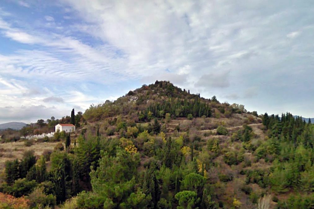
| On the conical hill named “Agia Triada” above the village Silimna in Arkadia |
| Region > Prefecture: |  |
| Peloponnese Arcadia | |
| Municipality > Town: | |
| City of Tripoli • Silimna | |
| Altitude: | |
|
Elevation ≈ 965 m (Relative Height≈65 m) |
| Time of Construction | Origin | |
| Unknown | Unknown |
|
| Castle Type | Condition | |
| Castle Ruins |
Few Remains
|
A few castle ruins on the plateau of the top of a conical hill named “Agia Triada” above the village of Silimna in Arcadia, 5 km. west of Tripoli.
Location & Strategic Scope
The position has visual contact with the castle at Trikorfa, with Davia and with the castle in Kokkinies, at a nearby hill to the NE.
It also controls the mountain pass from the Tripoli plain to the Elissonas valley.
History
The history of the castle is not known. The way some buildings were built with rough stones, connected with strong lime mortar and admixture of tiles, indicates that they are either from the Byzantine period or the Frankish period. Also, remains of an ancient wall indicate that the site was fortified in Antiquity. Perhaps it was the acropolis of an ancient –unidentified at present– city.
The one and only time we encounter the castle in a historical source is its entry as Silimo in the Venetian catalogue of the castles of the Morea of 1467, where it is noted that it is destroyed. (However, we cannot be absolutely sure that Silimo is identical with Silimna.)
It is worth noting that the 19th century researchers W.M. Leake and W. Loring identified the castle of Silimna with the dry stone fortification on the opposite hill, at Kokkinies. However, they probably had not noticed the ruins on the hill of Agia Triada.
Structure, Fortification & Buildings
The top of the hill forms a plateau of 15✖28m., with an area of 420sq.m.
The northern slope is steep, while the eastern one is smooth. To the east, where the current access path from the village ends, the gate must have been located, at the point where the foundations of a small tower measuring 2✖2m are observed. Traces of a cistern are preserved nearby.
On the northern side of the castle are the remains of a tower 2.30✖2.40 at a surviving height of 1m. The wall of the tower, built with rough stones and lime mortar, is half a meter thick. Next to it are the ruins of a building measuring 2.30✖2.40m. From this point to the supposed eastern gate, a wall made of massive stones begins, which appears to be ancient.
The “ancient” wall reaches the topographic mark of the GYS and from there continues as dry stone (which does not appear to be ancient).
To the west, at the root of the hill, there are foundations of a building that may have been a tower, a remnant, perhaps, of an external fortification at the foot of the hill.
On the south side of the hill there are traces of walls.
| First entry in Kastrologos: | March 2025 |
Sources
- Α. Ι. Μπάλλας, «Τα μεσαιωνικά κάστρα του Μαινάλου», Πελοποννησιακά ΚΑ΄, 1995, σελ.129-192, 166-169
- ΑΡΧΑΙΟΛΟΓΙΚΟΝ ΔΕΛΤΙΟΝ, τεύχος 52/Β1 –1997, σελ. 228
|
|
| Access |
|---|
| Entrance: |
| Free access |