Agios Andreas, North Kynouria, Arcadia,Peloponnese
Acropolis of Agios Andreas
or Acropolis of Anthini
1
2 / 10

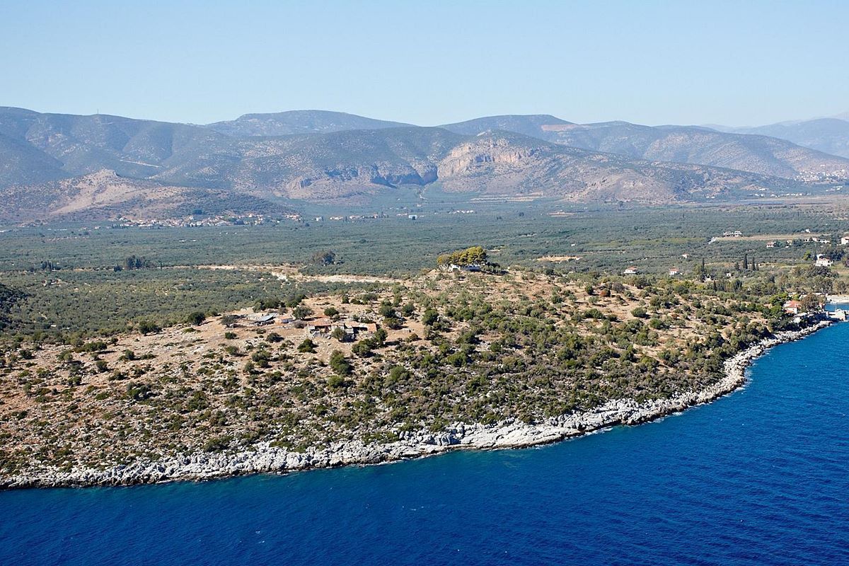
the hill from NE
3 / 10

part of the west wall (photo D.P. Loukissas)
4 / 10

part of the NW wall (photo D.P. Loukissas)
5 / 10

6 / 10

7 / 10

tower in the middle of the west side of outer circuit
8 / 10

tower at south wall (photo: Anna Magdalena Blomley)
9 / 10

ancient tower of inner circuit (photo: Anna Magdalena Blomley)
10 / 10

THE END
| Location: |
| On a flat hill on the beach of Agios Andreas, 3km NE of the village Agios Andreas |
| Region > Prefecture: |  |
| Peloponnese Arcadia | |
| Municipality > Town: | |
| City of North Kynouria • Agios Andreas | |
| Altitude: | |
| Elevation ≈ 48 m |
| Time of Construction | Origin | |
| Various periods | ANCIENT |
|
| Castle Type | Condition | |
| Ancient City |
In Ruins
|
Ruins of an ancient fortified city, inhabited until the first centuries of the Byzantine Period.
It is located on a low coastal hill called “Nisi”, 3 km northeast of Agios Andreas in Kynouria.
History
The ancient city located on the Nisi hill in the beach of Agios Andreas was called Anthini. It is also known as Athini or Anthana. In the past, some researchers believed that here was the ancient Thyrea, but this is wrong.
Anthini and Thyrea were the two most important cities of Thyreatis. Thyrea was located in an inaccessible position in the interior of Kynouria and controlled the passes (being the thira between the territory of Argos and that of Sparta), while Anthini was located at the southern end of the plain and was the port of the region.
Anthini is believed to have existed at least since the 5th century BC, possibly earlier. The construction of the ancient walls is estimated to have taken place in the late 5th or early 4th century BC. The area continued to be inhabited during the Hellenistic and Roman periods. Few finds have been found from later periods, with the exception of coins of Justinian.
Indications for historical development are, of course, also given by the additions made to the ancient walls, which date back to the Early Byzantine Period.
The city seems to have been abandoned after the 7th century, as there are neither historical references nor archaeological finds from more recent times. The beginning of pirate raids on the Greek seas by the Saracens and other invaders probably made the coastal town vulnerable and not sufficiently safe, leading the inhabitants to seek a safer place inland.
The traveler W. Leake, who visited in March 1806, gives us the information that when 100 years before the Venetians were building Palamidi in Nafplio, they used the stones from the walls of Agios Andreas as building material. As a result, almost nothing remained.
Anthini is mentioned by Thucydides in the History of the Peloponnesian War. Also by Pausanias, Harpocrates, Stephen of Byzantium and Pliny
Structure, Fortification & Buildings
The place where the ancient city is located is a rocky, narrow hill on the sea, on the North-South axis. The hill, with an altitude of 48m, is an extension of Lagovouni Mountain. Its eastern side is on the sea. The northern side rises with a smooth slope above the mouth of the Charadros River (or Vrasiatis) and the little port of Agios Andreas. The western side is steeper and faces the plain of Thyreatida, while the southern side is connected via a ridge to Lagovouni.
At the top, there is a newer chapel of Agios Andreas.
This is a large fortification with an area of 81,000 sq.m. and an external perimeter of 1,156 meters. There were two fortifications, the outer one and a much smaller inner one with a perimeter of 95 meters, around the chapel of Agios Andreas. The space within the inner fort was the citadel of the ancient city.
The walls are mostly constructed with the polygonal system (in two different time periods), with the surface of the stones smoothed and the joints carved. In some sections, an isodomic system belonging to a third building phase, perhaps of the Hellenistic era, is also observed.
In the original form of the fortification, the wall protected the entire hill from all sides. Today, the wall is not visible along the entire perimeter. It is preserved only in fragments. Even in the places where the wall is preserved, it is in ruins and only the foundations are preserved. However, in some places up to five layers of stones are preserved, reaching a maximum height of 2.70 m.
The same in the inner fort, where in some parts of it no traces of walls are found, either because they were completely destroyed, or because they never existed as in some places there are high, steep rocks.
In the inner fort, only one tower is preserved (photo 9) in the northeastern part and remains of two others from later times, for the construction of which material from the ancient fortification was used in a second use.
The thickness of the wall is not the same in all places. On the northern side it is 2.80-2.90 m, on the western side 2.30m and in the Byzantine extension 2m.
The outer circuit had 21 rectangular towers, at irregular order. They are either preserved at a low height or most of them at the level of the foundations. The most numerous towers are located on the eastern and northern sides, which were the most vulnerable, while the western side, which is naturally fortified, has the fewest.
The dimensions of the towers vary, with a front length of 4.75 to 5.70m. and a depth of 2.40 to 2.55m.
In general, most of the fortification that has survived are ancient structures. In some places there are later additions to the ancient wall. According to excavation data, the extension of the outer enclosure to the north, towards the harbor, and certainly the two towers on the acropolis, belong to the Byzantine period.
A large part of the hill, and especially on its northwestern side, has been filled in and leveled. This leveling work must have been carried out towards the end of the Roman Period, around the 3rd or 4th century AD.
During the 1962 excavations, a large number of unspecified rectangular buildings were discovered on the northeastern slope of the hill, two rock-cut olive presses, numerous cisterns on the eastern and southern sides, and traces of wagon tracks from an ancient road in the rock on the western side of the hill.
| First entry in Kastrologos: | March 2025 |
Sources
- Παναγιώτης Φάκλαρης, «Αρχαία Κυνουρία - Ανθρώπινη Δραστηριότητα και Περιβάλλον», ΕΚΔΟΣΗ ΤΟΥ ΤΑΜΕΙΟΥ ΑΡΧΑΙΟΛΟΓΙΚΩΝ ΠΟΡΩΝ ΚΑΙ ΑΠΑΛΛΟΤΡΙΩΣΕΩΝ, ΑΘΗΝΑ 1990, σελ.47-55
- Θ. Καράγιωργα, Αρχαιολογικον Δελτίον, τεύχος 18/Β1–1963, σελ.89
- Anna Magdalena Blomley, «A Landscape of Conflict?-Rural Fortifications in the Argolid (400–146 BC)», Archaeopress Publishing, Oxford, 2022, σελ.168-170
- Δημήτριος-Περσέας Λουκίσσας, «Αργολίδας-Κορινθίας Περιήγησις», τόμος Β’, Ανοιχτή Πόλη, Αθήνα, 2024 σελ. 205-206
|
|
| Access |
|---|
| Entrance: |
| Free access |