Tracheia, Epidaurus, Argolis,Peloponnese
Castle of Tracheia


| Location: |
| On a hill between the villages Tracheia of Argolis and Agia Eleni of Troizinia |
| Region > Prefecture: |  |
| Peloponnese Argolis | |
| Municipality > Town: | |
| City of Epidaurus • Tracheia | |
| Altitude: | |
|
Elevation ≈ 538 m (Relative Height≈120 m) |
| Time of Construction | Origin | |
| Various periods | Unknown |
|
| Castle Type | Condition | |
| Castle Ruins |
In Ruins
|
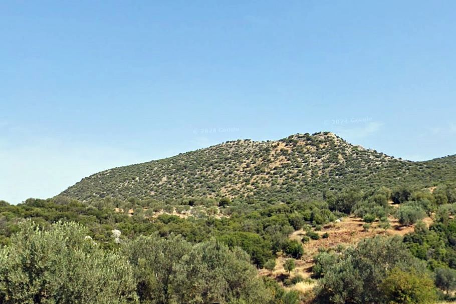
Ruins of ancient fortifications with medieval additions on the mountain "Bika" or "Kastro" located between the villages of Tracheia (of Argolis) and Agia Eleni (of Troizinia).
History
We know nothing about the history of the fortification. There are no references from historical sources, and no researcher has studied it except for Ioannis Peppas in the mid-1980s.
According to Peppas, the ancient fortification may date from the 7th century BC, while the later dry-stone fortification may date from the early 13th century, when the Franks and the lord of the Duchy of Athens, Othon De La Roche, were trying to bring the area under their control, and for this reason they had created numerous dry-stone fortifications on the hills of Argolida and Corinth.
Structure, Fortification & Buildings
The mountain has an elongated ridge with two peaks. The northwestern peak is at 538m and the southeastern at 528m. The distance between the peaks is 550 meters.
The ridge is accessible only from the southern side, while the northern one is steep and inaccessible.
A small fortress was created on each of the two peaks in ancient times. Their walls consist of blocks measuring approximately 0.5✖0.5✖0.7m. There was no wall on the north side of both fortresses.
In the northwestern fortress, the western edge (where the entrance, probably) was protected by a circular tower (photo 4,5), which survives at a low height. In the southeastern fortress, which is slightly smaller, there was no tower.
During the Middle Ages (probably in the early 13th century) these two small fortresses were joined by a dry-stone wall that was constructed on the southern slope, slightly lower than the ridge (see LAYOUT). In the middle of this wall, a circular tower with a diameter of 6m was built.
In this way, a relatively large castle was reated with two citadels and an inner yard.
Since the medieval expansion, the dry stone wall has been largely destroyed, while only a section of the northern side of the tower survives.
The medieval wall is constructed with large semi-finished stones on the inner and outer sides, while the gap in between is filled with smaller stones. It is a style that characterizes many of the Frankish fortifications of the region during the De La Roche era.
Outside the fortress, on the slope below the southeastern ancient fortress, the foundations of three circular towers survive (photo 6). The construction of these towers shows that they are newer than the ancient fortifications, but older than the drystone (Frankish?) additions.
| First entry in Kastrologos: | March 2025 |
Sources
- Ιωάννης Ε. Πέππας, «Μεσαιωνικές σελίδες της Αργολίδος, Αρκαδίας, Κορινθίας, Αττικής», Αθήνα 1990, σελ.287
- Photos 2-5 Δημήτριος-Περσέας Λουκίσσας, συγγραφέας της σειράς «Αργολίδας-Κορινθίας Περιήγησις», Ανοιχτή Πόλη, Αθήνα, 2024
|
|
| Access |
|---|
| Entrance: |
| Free access |