Asprovalta, Volvi, Thessaloniki,Central Macedonia
Castle of Kouledes of Asprovalta


| Location: |
| On an overgrown hill 4 km NE of Asprovalta, above the modern Egnatia Highway, at the 399th kilometer. |
| Region > Prefecture: |  |
| Central Macedonia Thessaloniki | |
| Municipality > Town: | |
| City of Volvi • Asprovalta | |
| Altitude: | |
|
Elevation ≈ 170 m (Relative Height≈50 m) |
| Time of Construction | Origin | |
| Unknown | BYZANTINE |
|
| Castle Type | Condition | |
| Castle Ruins |
Few Remains
|
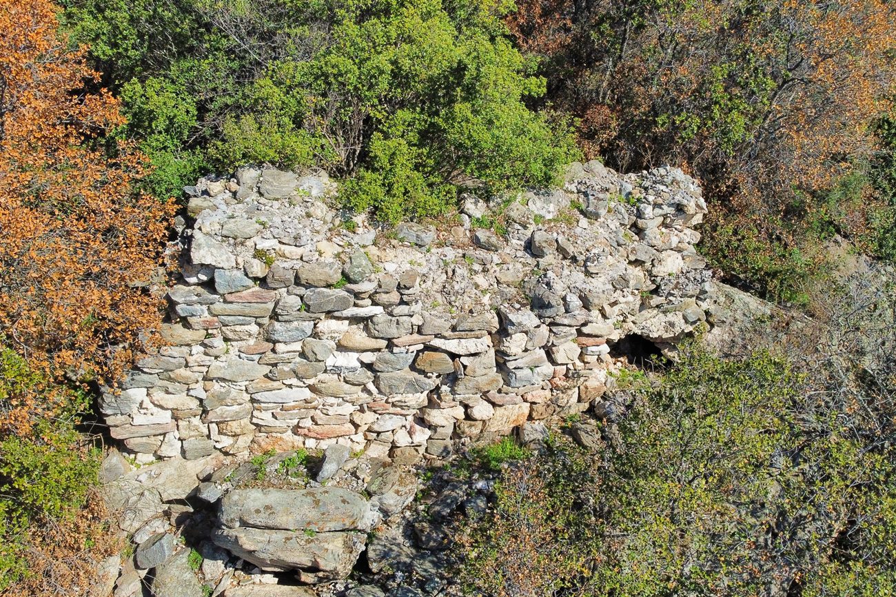
Few ruins of a Byzantine fortification on a verdant hill 4km NE of Asprovalta, in Macedonia.
Location & Strategic Scope
The (Upper) Castle of Kaledes is located on a conical hill at the foot of the Kerdyllian Mountains. All its sides are steep. In addition, the entire eastern side of the hill from north to south, is protected by a stream.
The most vulnerable side of the castle seems to have been the northwestern one, which is connected by a narrow neck to the rising slope of the mountain.
From the castle there is excellent visibility of the wider area, the Strymonikos Gulf and the Via Egnatia (ancient and modern).
The ruins of the castle were discovered by chance, after a forest fire in 2004. Today the vegetation has flared up again, and the hill is overgrown and difficult to access.
The ruins of the castle are located a little higher and very close (about 500m) from another castle, the Asprovalta Station. The name of the wider area is “Kouledes” which in Turkish means “Castles”. Apparently the name Kouledes – in the plural – is due to the existence of the two neighboring castles and the name survived, although in recent years (before 2000) the existence of the two castles had been almost forgotten.
History
The history of the castle is unknown. The neighboring castle, which we call Asprovalta Station or Lower Castle of Kouledes, is believed to have been the “mutatio Pennana” station of the Egnatia Odos mentioned in the Bordeaux itineraries (Itinerarium Burdigalensis – early 4th century AD). The Station dates from the Early Byzantine Period, and was in use throughout the Byzantine Period until the early Ottoman period.
It is certain that these two castles coexisted for a time, and there was apparently defensive cooperation between them.
Due to its proximity to the Station (which was basically a fortress), we should consider it certain that the castle on this page was not a fortress. It was probably a fortified settlement or perhaps a monastery.
We do not have any reliable indication on the date of construction. The use of mortar indicates that it was not ancient. The most probable hypothesis is that the site was fortified and inhabited in the first centuries of Byzantium.
Structure, Fortification & Buildings
The castle consists of fortification ruins on the plateau of the summit and of scattered piles of stones south of the summit, which are probably the remains of buildings and fortifications from some settlement.
The citadel, that is, the upper part of the castle, consists of a small plateau, surrounded by a wall, the trace of which is visible almost along the entire perimeter of 70-80m.
The construction of the wall consists of stone masonry with lime mortar between the stones. The most characteristic element of the fortification is a section of the southern wall 5 meters long, 1.80m high and 1.5m thick (photo 1-3).
On the eastern side of the castle’s citadel, a section of the wall (photo 5) is preserved, which does not exceed 2 meters in height. Other sections of the wall are also preserved, but it is impossible to photograph them due to the dense vegetation.
Below and south of the citadel, at a distance of about 100 meters, extends, as mentioned above, an area with scattered ruins. What stands out here is a water tank (cistern). Its shape is rectangular and the internal dimensions are 3.2✖4.3 meters. The northern side of the tank reaches a height of almost 3 meters, while the other sides are preserved at a height of 1-1.5 meters. In several places, the plaster of the internal walls of the tank is preserved.
A few meters next to the tank, a corner of a wall is preserved (photo 4). Throughout the rest of the area, piles of stones from buildings and scattered ceramics can be observed.
| First entry in Kastrologos: | April 2025 |
Sources
- Presentation, research and photos by Sakis Amfitreidis and his blog ΑΜΦΙΤΡΕΙΔΗΣ (March 2025)
- Ευάγγελος Παπαθανασίου- Μαρίζα Τσιάπαλη, «Η Κλεισώρεια Ρεντίνης-Στεφανηνών: Ορισμός -Χαρακτηριστικά- Αμυντική οργάνωση μέσα στο χρόνο», ΑΠΟ ΤΑ ΜΑΚΕΔΟΝΙΚΑ ΣΤΑ ΘΕΣΣΑΛΙΚΑ ΤΕΜΠΗ, σελ. 33 και 37-38, , 2019.
- Α. Τοκμακίδου-Π. Φωτιάδης, «Τοπογραφία Βυζαντινής και Μεταβυζαντινής Βόλβης, Τεκμήρια Ιστορίας στον Δήμο Βόλβης» (Αφιέρωμα στα 40 χρόνια προσφοράς του καθηγητή Νικολάου Μουτσόπουλου στην γη της Μυγδονίας), Πρακτικά Ημερίδας, Θεσσαλονίκη 2019, σελίδες: 156-157.
- Ευθυμία Ντάφου - Μαρία Τσιάπαλη, «Τοπογραφικά βυζαντινών χρόνων στον μυχό του Στρυμονικού κόλπου: επισκόπηση μαρτυριών», Τεκμήρια Ιστορίας στον Δήμο Βόλβης - Πρακτικά Ημερίδας, Θεσσαλονίκη 2019, σελ. 90-93 και σχόλιο 43.
- Αναστασία Τουρτα, Αρχαιολογικόν Δελτίον, τεύχος 47/Β2-1992, σελ.444.
|
|
| Access |
|---|
| Approach to the monument: |
 διαδρομή προς το κάστρο |
| Entrance: |
| Free access |