Peristerona, Volvi, Thessaloniki,Central Macedonia
Castle of Peristerona
1
2 / 20

south side
3 / 20

wall fragment at the south side
4 / 20

wall fragment at the south side, view from above
5 / 20

ruins of a tower at the top
6 / 20

west wall
7 / 20

west wall
8 / 20

west wall
9 / 20

the steep north slope reaching lake Volvi
10 / 20

fallen rock of NE corner with part of wall on it
11 / 20

fallen rock of NE corner with part of wall on it
12 / 20

ruins of a building partly under the waters of the lake
13 / 20

remains of a gate (?) at the NE corner
14 / 20

fragment of the east wall
15 / 20

ruins of a tower (?) at the east side
16 / 20

position of a fortified settlement
17 / 20

remains of the south wall of the settlement
18 / 20

the big picture
19 / 20

traces of a stone-paved road
20 / 20

THE END
| Location: |
| On a low hill at the southern bank of Volvi lake, 2.5km SE of the village Peristerona |
| Region > Prefecture: |  |
| Central Macedonia Thessaloniki | |
| Municipality > Town: | |
| City of Volvi • Peristerona | |
| Altitude: | |
|
Elevation ≈ 62 m (Relative Height≈20 m) |
| Time of Construction | Origin | |
| Uknown | BYZANTINE |
|
| Castle Type | Condition | |
| Castle Ruins |
In Ruins
|
Ruins of a lakeside Byzantine castle on a low hill, called Kales, on the southwestern shore of Lake Volvi.
History
The history of the castle is unknown.
Scholars report that “at this location there is a fortified settlement probably from Byzantine times”. (Tokmakidou/Fotiadis, 2019)
From the medieval history of the region we know that the region of Volvi remained a Byzantine province throughout the Byzantine Period, until the final conquest by the Ottomans in 1383, with the exception of the Latin Rule (1204-1221/4) and the short-lived annexation to the Serbian Kingdom (1345-1371). During this long history we have no mention from historical sources that would help to identify the castle of Peristerona. It could perhaps be the Volvon fortress mentioned by Procopius in Peri Ktismaton, but the general belief is that this name refers to the castle in the middle of the lake (which is visible in some years).
During the Ottoman occupation, what we know about the area is that Peristerona is mentioned as a village in the 15th-16th century under the name “Ogrek Buyuk” or “Ogrek Küçük”. In the 17th-18th century it is recorded as a Muslim settlement under the name “Ogrek”. In 1927 it was renamed "Peristerona".
The wall construction of the fortification (stone construction with lime mortar and limited use of tile fragments in the gaps) clearly indicates construction in the Byzantine Period without there being any evidence for a more precise dating.
Below the castle is a large area with an enclosure that appears to have been a fortified settlement and right next to it are traces of a paved road. It is possible that the Egnatia Odos passed through this point, along which there were fortresses/refueling stations. In other words, there is a possibility that the fortification was connected to the Egnatia, but this is just a hypothesis.
Structure, Fortification & Buildings
The top of the castle is at an altitude of 62 meters, from where there is great view in the wider area of Lake Volvi.
Today, ruins of the fortification with a perimeter of approximately 300-350 meters are preserved. The construction of the wall consists of semi-processed stones with binding mortar. There are scattered ceramics throughout the area.
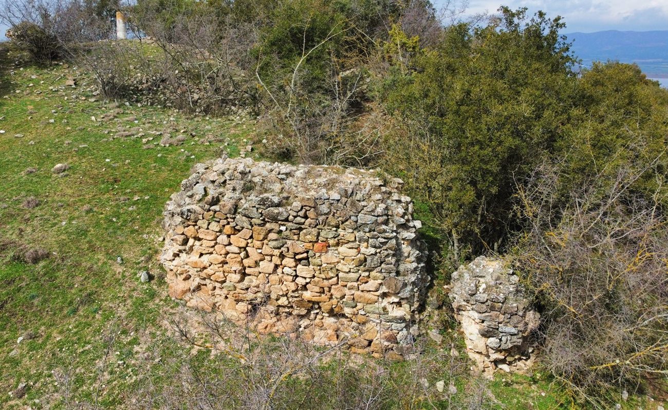
The most vulnerable side of the castle was the south. The best preserved section of the wall is also preserved on this side. It is a section of wall 5-6 meters long, 3 meters high and 1.30 meters thick (photo 1-4, 20).
The south side was also the highest point of the castle. There is also a topographic column of the Greek Army there. Next to it there are ruins of a wall with a thickness of 1.5m at a low height and stone piles, remains of a large building – probably a tower – that has collapsed. (photo 5).
On the western side, the wall has a visible trace along its entire length. Some sections are preserved at a low height of 1-1.5 m (photos 6-8).
On the northern side, which is quite sloping, the wall is not visible and has been covered by vegetation. The lower slopes of this side are reaching the waters of Lake Volvi. What is interesting here is a piece of the wall on a rock that has been detached and has rolled lower, towards the lake (photos 10,11). This is a corner of a wall with a thickness of 0.70m.
As mentioned above, below the northern side is the bank of Volvi. On the shore there are buildings built with stones and mortar, which seem to extend into the water (photo 12).
In the northeastern corner there is a section of wall that was probably a gate to the castle (photo 13). This is a section with an opening of 1.30m and a height of approximately 1.20m.
On the eastern side there are a few sections of wall preserved at a very low height (photo 14). Approximately in the middle of this side there are isolated ruins that are preserved at a height of 3-3.5m (photo15). These are probably the remains of a tower.
Adjacent to the castle, to the southeast, there is a large agrarian area with a perimeter of approximately 900 meters. In this area, a low wall survives on the south and west sides (photos 16,17). This wall also consists of stones with binding mortar. A wall probably survives on the east side as well, but an on-site investigation was not possible due to the existence of a sheepfold with dogs and sheep at this point. This wall was pointed out to us by a shepherd in the area and he informed us that there was an old settlement within the enclosed area next to the castle.
Next to the south wall of the settlement, on the modern dirt road, there are traces of a paved road (photo 19) which the same shepherd pointed out to us. Traces of a paved road also exist at another point, specifically half a kilometer east on the same dirt road.
| First entry in Kastrologos: | March 2025 |
Sources
- Presentation, research and photos by Sakis Amfitreidis and his blog ΑΜΦΙΤΡΕΙΔΗΣ (March 2025)
- Α. Τοκμακίδου-Π. Φωτιάδης, «Τοπογραφία Βυζαντινής και Μεταβυζαντινής Βόλβης, Τεκμήρια Ιστορίας στον Δήμο Βόλβης» (Αφιέρωμα στα 40 χρόνια προσφοράς του καθηγητή Νικολάου Μουτσόπουλου στην γη της Μυγδονίας), Πρακτικά Ημερίδας, Θεσσαλονίκη 2019, σελίδες: 148-149.
|
|
| Access |
|---|
| Approach to the monument: |
| From the village of Peristerona we follow a dirt road heading east towards the lake, which in 2 kilometers leads us directly below the north side of the castle. |
| Entrance: |
| Free access |
| Other castles around |
|---|
| Tower of Arethousa |
| Tower of Galatista |
| Castle of Mavrouda |
| Tower of Bourgas |
| Castle of Nigrita |
| Tower of Skepasto |