Vlachaiika, Ermionida, Argolis,Peloponnese
Castle of Mylorema


| Location: |
| On a mountain 3.5km NW of the village Vlachaiika in Troizinia |
| Region > Prefecture: |  |
| Peloponnese Argolis | |
| Municipality > Town: | |
| City of Ermionida • Vlachaiika | |
| Altitude: | |
| Elevation ≈ 400 m |
| Time of Construction | Origin | |
| perhaps 13th cent. | FRANKISH |
|
| Castle Type | Condition | |
| Castle Ruins |
In Ruins
|
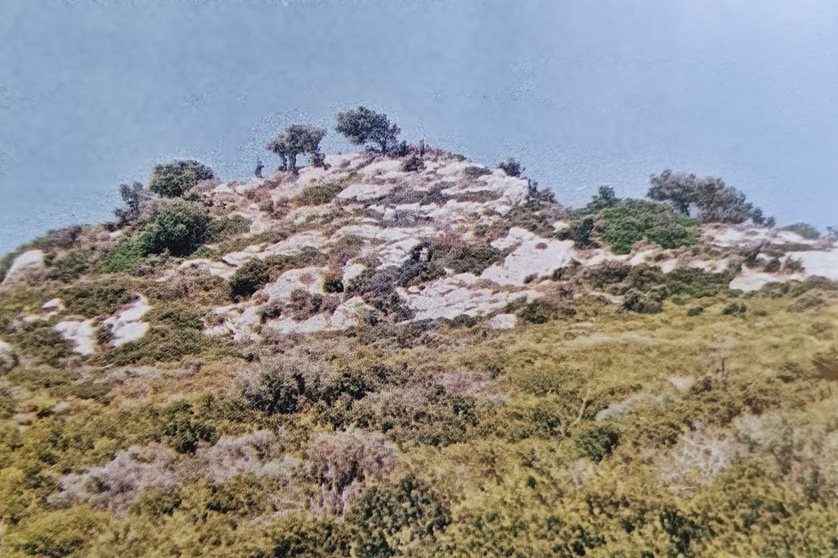
Few ruins of a small castle, dominated by the remains of a tower, on a remote hill in the hinterland of Ermionis.
Location & Strategic Scope
The hill is a steep, limestone rock that stands out from the sedimentary terrain of the hilly area that surrounds it. It is located on a ridge, which on the maps of the Greek Meteorological Service is marked with the name “Kastro”.
Although it is relatively far from the sea, it has a very good view of the Gulf of Hydra to the south and the southern side of the Saronic Gulf to the east. It also has visual contact with the Venetian castle Thermisi.
The site is located in Argolis, in the Municipality of Ermionida, but is very close to the border with Troizinia. It is located 5km NE of the village of Solinari in Argolida, but the nearest village (3.5 km. to the SE) is Vlachaiika, which belongs to Troizinia and the Regional Unit of the Islands of Attica.
At the northwestern foot of the hill is the bed of a stream called Mylorema. Another branch of the same stream passes south of the castle. Obviously, the castle took its name from the stream.
History
The castle of Mylorema is mentioned in the Chronicle of Sphrantzis during the negotiations between the Despotate of the Morea and Venice (Lambrinidou, 1950). Then, in 1394, the despot Theodore I Palaiologos, due to the Venetian naval blockade, was forced to return to Venice the castles of Argos, Lerni and Thermis (which he had taken by surprise in 1388). As part of that settlement, the Venetians returned Megara (to the Duke of Athens and ally of Mystras, Nerio) and the Castle of Mylorema to the Byzantines.
According to Dorotheos of Monemvasia (Sathas, 1868), during the siege of Nafplio by the Turks in 1537, Kassim Pasha “went to the Towers of Kastri and was unable to take them, and burned them, and they surrendered so that they would not be burned, [...] then he also took the Palaiologoi, Sir Andronikos, Sir Nikolaos, Sir Theodore, and Sir Demetrios and in Argos he cut off their heads; and then Thermisi was also surrendered”.
In this narrative it is believed that the Towers of Kastri is the Castle of Mylorema.
It may seem a bit far-fetched that the stream retains the same name after so many centuries, but, apart from the name, the location of the castle and its proximity to Thermisi make us believe that the identification with the Castle of Mylorema mentioned in the sources is rather correct. The identification with the Towers of Kastri of 1537 is less obvious, but this too is probably valid due to its proximity to Thermisi and the fact that the fortress is basically 2-3 towers.
Based on these, the history of the castle is outlined as follows:
It was initially built either towards the end of the Middle Byzantine Period or at the beginning of the Frankish rule, when the area was ruled by the Delaros of the Frankish Duchy of Athens. We will describe it with reservation as “Frankish”.
After 1311 it passed to the heirs of the Duchy of Athens, the De Briennes and then the D’Engiens.
In 1385 it was purchased by the Venetians (along with the rest of Argolis) and in 1394 it was returned to the Byzantines of Mystras. After the conquest of the Peloponnese by the Ottomans, it was seized by the Venetians, probably in 1458.
In 1537 the Turks conquered it and destroyed it.
Structure, Fortification & Buildings
What dominates the rock is the ruin, at a low height, of a large tower measuring 5✖18m at the eastern end of the rock. The walls of the tower are 1.5m thick and are built with slab-like stones and mortar (mud).
Further west on the hill there are other towers. The foundations of at least two can be observed, measuring 14✖4 and 10✖4, while other remains in the area create the impression that there were other towers in a dense arrangement instead of a fortification wall. The long side of the towers faces south.
| First entry in Kastrologos: | March 2025 |
Sources
- Ιωάννης Ε. Πέππας, «Μεσαιωνικές σελίδες της Αργολίδος, Αρκαδίας, Κορινθίας, Αττικής», Αθήνα 1990, σελ.120-121
- Κ. N. Σάθας, «Τουρκοκρατουμένη Ελλάς», Αθήνα 1869, σελ.284-288
- Μ. Λαμπρινίδου, «Η Ναυπλία», Αθήναι 1950.
|
|
| Access |
|---|
| Entrance: |
| Free access |