Agkitis, Prosotsani, Drama,Central Macedonia
Fortress of Aggitis


| Location: |
| On the hill above the cave of the source of Aggitis river in Macedonia |
| Region > Prefecture: |  |
| Central Macedonia Drama | |
| Municipality > Town: | |
| City of Prosotsani • Agkitis | |
| Altitude: | |
|
Elevation ≈ 215 m (Relative Height≈75 m) |
| Time of Construction | Origin | |
| Unknown | Early ΒΥΖΑΝΤΙΝΕ |
|
| Castle Type | Condition | |
| Castle Ruins |
In Ruins
|
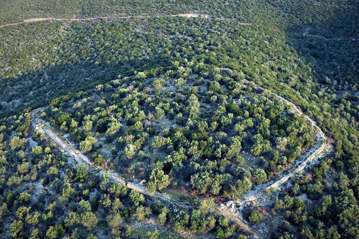
Castle ruins on the hill above the cave of Aggitis springs, at the foot of Mount Falakro, near the villages of Aggitis and Piges in the prefecture of Drama.
The Name of the Castle
The name “Aggitis Castle” is modern. Its original name is not known. It may be the historical castle of Panakas (see below). It is also referred to as “Maaras Castle”.
Maaras is the name of the area and comes from the Turkish mağara meaning “cave”, which cave is that of the Aggitis springs which is located under the castle and is the largest river cave in Greece (and one of the largest in the world) with a length of over 11 kilometers.
History
The history of the castle is unknown.
It has been suggested that it may be the Panakas castle referred to as kastellion and horion by historical sources (in a 12th century typicon of the Constantinopolitan monastery of Sotiros Pantokratoros, in a chrysoboul of 1321, etc.). This identification is not unlikely, although the only evidence we have in favor of it is that the Aggitis River during the Byzantine Period is also referred to as “Panakas”. But for the same reason, the castle of Panakas could also be the castle at Aggista Station or one of the other fortresses, ruins of which have been found near the Aggitis River.
The construction style shows that it is medieval and not ancient. The ruins of a large three-aisled basilica inside attest to its use and habitation during the Early Christian (at least) Period.
The relatively large area shows that it was a settlement and not a simple fortress. It is probably a fortified settlement of the Early Byzantine period and probably belongs to the large group of settlements in Macedonia that were abandoned after the 7th century (at the latest) when the raids of barbarian tribes intensified (culminating in the raids of Avars and Slavs in the late 6th and early 7th centuries).
However, it is possible that this particular castle was inhabited until the Late Byzantine Period. This is certain if the identification with the Panakaσ castle is proven.
Structure, Fortification & Buildings
The fortification wall is not preserved at a great height, but it is clearly visible along its entire length. The ruins of several cylindrical, quadrilateral and one polygonal towers can also be seen.
The perimeter of the wall is 585 meters long and encompasses an area of 24.500 sq.m. It is a relatively large castle.
Inside there are few ruins of buildings. The ruin of a large three-aisled basilica dominates. The area has never been explored and may hide interesting finds.
The wall construction system is stone masonry with strong lime mortar and, sporadically, bricks at the joints.
| First entry in Kastrologos: | February 2025 |
Sources
- Photos and Video by the user DIMITRIOS KATRANTZIS "Whispers of the Past" - The Unknown Castle (March 2024)
|
|
| Access |
|---|
| Entrance: |
| Free access. |
| Other castles around |
|---|
| Castle of Agio Pneuma |
| Castle of Stathmos Agkistas |
| Castle of Dafnoudi |
| Castle of Gazoros |
| Kale of Petroussa |
| Castle of Sfelinos |
| Castle of Zichna |