

Vevi, Florina, West Macedonia
Castle of Vevi
or Kaleto of Vevi

| Location: |
| On a hill 4.5 km SW of the village Vevi in Florina region of West Macedonia |
| Region > Prefecture: |  |
| West Macedonia Florina | |
| Municipality > Town: | |
| City of Florina • Vevi | |
| Altitude: | |
|
Elevation ≈ 805 m (Relative Height≈90 m) |
| Time of Construction | Origin | |
| Unknown | Early ΒΥΖΑΝΤΙΝΕ |
|
| Castle Type | Condition | |
| Castle Ruins |
Few Remains
|
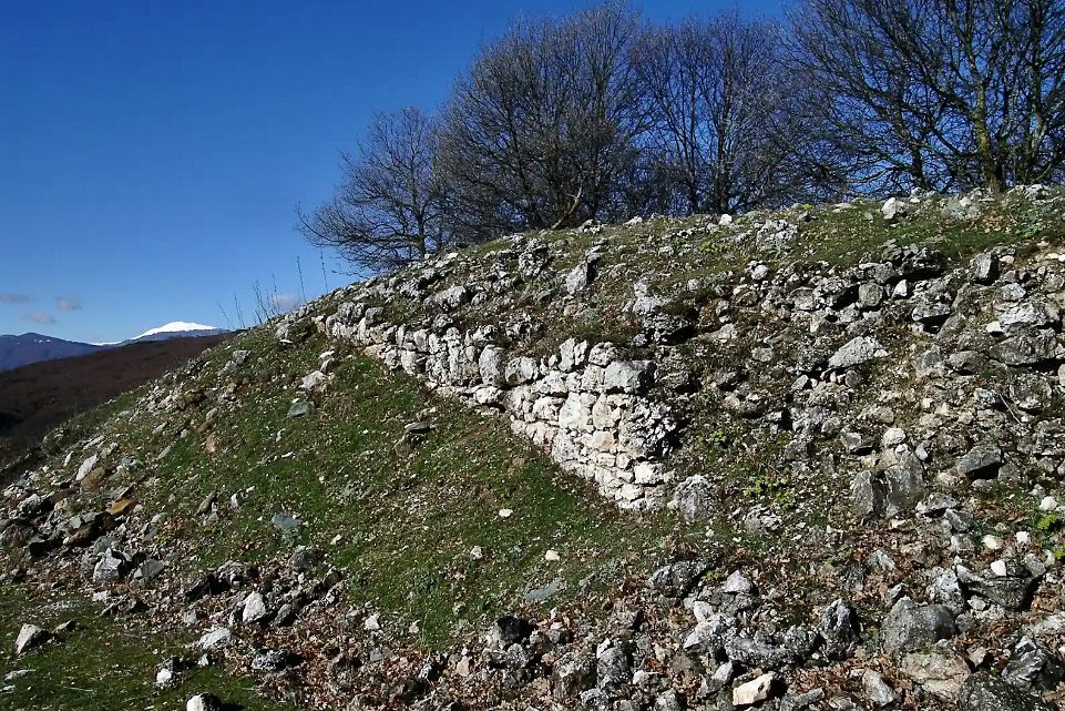
Few traces of a fortification enclosure on a hill SW of Vevi in the prefecture of Florina in Western Macedonia.
The hill is located on the right bank of the small river Rekata and near the pond “Alexandros” that was created after the stream was blocked for the needs of the lignite mine (the town used to be the center of a big lignite mining operation).
We know nothing about the history of the fortification. The use of mortar in the masonry indicates that it is not ancient. It is dated either to Late Antiquity or most likely to the Early Byzantine Period.
It is not possible to identify it with any settlement or fortress mentioned in historical sources.
The fortification, locally known as “Kaleto”, was discovered a few decades ago during works of ore exposure in the lignite mine.
In Vevi, there are mentions from historical sources of the existence of two ancient settlements, one of which was located on the trapezoidal hill next (to the north) to the town and the other on a hill located approximately 500 m south. These points have not been located with certainty, while Kaleto is not at either of these points.
Vevi was located on the Roman Via Egnatia and at this point a narrow passage is created – the “Kleidion pass” – between the heights of the Vernos and Voras mountain ranges. Logically, at such a strategic point there should have been several fortifications. Kaleto was one of them.
Access to Kaleto is difficult and very dangerous, since many rural roads that pass between the mine’s excavations have suffered subsidence. The map below shows the –relatively– safest route. But even on this route, the visitor should be very careful and mind the danger signs that have been placed, because new faults may have been created.

the preferred route before Kaleto vevis
| First entry in Kastrologos: | February 2025 |
Sources
- Info and photos by Yiannis Daikopoulos
- Δημήτρης Σαμσάρης, «Ιστορική Γεωγραφία της Ρωμαϊκής Επαρχίας Μακεδονίας - Το τμήμα της σημερινής Δυτικής Μακεδονίας», Θεσσαλονίκη, ΕΤΑΙΡΕΙΑ ΜΑΚΕΔΟΝΙΚΩΝ ΣΠΟΥΔΩΝ, 1989, σελ. 184 (online)
|
|
| Access |
|---|
| Entrance: |
| Free but dangerous access. |
| Other castles around |
|---|
| Koules of Florina |
| Fortress of Petres |
| Castle of Setina |